 |
| Boat launch ruins and dead tree—Crystal Bay |
Surrounded by three bays—Burnet, Crystal, and Scott—Brownwood thrived for two decades, taking off in the 1940s as Humble Oil executives built homes along the Houston Ship Channel. Brownwood's fortunes declined, however, when Hurricane Carla slammed ashore more than 100 miles down the coast at Port O'Connor on September 11, 1961. The Houston metropolitan area, which includes the city of Baytown, was on the "dirty" or wet side of the Category 5 hurricane, and Brownwood sustained a ten-foot storm surge. The community was devastated and never fully recovered.
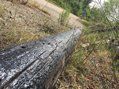 |
| The last utility pole in Brownwood, Crow Road (photographed July 2016) |
Over the next twenty-two years, a series of storms inundated Brownwood as the peninsula continued to subside, the result of decades of excessive groundwater extraction. In the end, the elevation of Brownwood dropped by ten feet. In August 1983 Hurricane Alicia sealed the neighborhood's fate as utilities were cut off and more than 300 residential properties were condemned. Those actions set in motion a series of lawsuits and property buyouts.
By the early 1990s, most of the houses had been torn down and the debris cleared, but almost thirty years later, there are still plenty of signs of Brownwood's past; you just have to know where to look for them. The easiest place to start is on the shoreline.
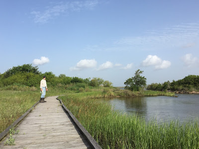 |
| Tracey's Seine Sampling Boardwalk |
Just past the Brownwood Education Pavilion (the highest point in the Nature Center), Crow Road is blocked by a gate, but there is a small parking area on the right-hand side of the road. Leave your car there and, after walking around the gate, cross a bridge. Immediately to the right is Tracey's Seine Sampling Boardwalk. (In case you are curious, seining is a method of collecting aquatic samples using a large seine net or a smaller handheld net.) As you cross the boardwalk, look for signs of wildlife below it; you just might see a group of blue crabs scurrying in the sand.
 |
| Basket flowers and bumblebees |
At the end of the boardwalk, the path narrows as it heads toward Crystal Bay. When I was there this summer, basket flowers, some as high as six feet, were buzzing with bumblebees. When you get to the bay, walk along the shore among the riprap and broken concrete slabs, but be careful—the surfaces are slick and uneven. Ten to fifteen feet from the land, you will also see the concrete foundation for a boathouse.
 |
| Boathouse ruins |
The best time to explore the shoreline is during low tide, especially after a cold front has blown through and pushed the water out of the Ship Channel into Galveston Bay. Low tide provides greater access to the beach and a better chance of discovering hidden objects, such as broken cups and saucers, otherwise buried in the sand.
 |
| Shell, brick fragment, and crockery on Wooster Point |
One of my favorite spots in the Nature Center is Wooster Point, where Crow Road / Bayshore Drive meets Mapleton Avenue. A short path leads to the point and a covered picnic area. Next to the structure is a footprint of a house, its pink ceramic tile still glued to the bathroom floor. It must have looked stylish in its heyday of the 1950s. Its geometry of squares and tiles still mesmerizes.
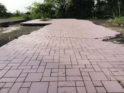 |
| House foundation, Wooster Point |
You have to use your imagination to see what used to lie beyond Wooster Point as the ground sloped toward Scott Bay. Wooster Cemetery was a small family graveyard associated with the original community of Wooster (established in 1892). The first burial, for ten-year-old Martin Elmar Wooster, occurred in 1894, and the last person buried there (in 1969) was the poetically named Edna Sjolander, who died at age forty-three. As subsidence took its toll on Brownwood, the cemetery slowly slipped underwater. Most of the graves were relocated, and by 1980 the cemetery had disappeared and only empty crypts were visible at low tide.
 |
| My colleague Georgeann standing on riprap at Wooster Point |
On a trip to the Nature Center this summer, my colleague Georgeann and I investigated Wooster Point. In the photograph above, she stands with her back to what used to be Wooster Cemetery. The stretch of land in the distance, rising eight feet above the channel, is the southern section of Goat Island, which was partially reconstructed in 2003-2004.
Georgeann and I were doing reconnaissance for a Lee College Honors class, the Human Condition, that we team-teach. For a unit entitled "How Do We Connect with Nature?" we have scheduled a field trip to the Nature Center, where our students will learn about and consider the historical, cultural, and environmental impacts on Brownwood and the Baytown Nature Center.
 |
| Brownwood Education Pavilion, looking toward the San Jacinto Monument |
To continue your tour, reverse your route past the Education Pavilion, down Crow Road. If you want to explore the Children's Nature Discovery Area and the public fishing piers, take a left where the road forks on Bayshore Drive. Turn right at the fork to see the most spectacular ruins of Brownwood, the first of which is easy to miss. Look for a dirt road leading to a popular fishing spot on Burnet Bay. Buried in the weeds on the left is the outline of a swimming pool.
 |
| Overgrown swimming pool |
Beyond the pool, hidden in a tall stand of trees on the southern side, is a house foundation. Crawl through the thicket (how can you resist?) and you will find a rough green flooring affixed to the concrete slab, presumably to provide a textured surface for walking around the pool.
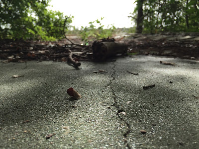 |
| Foundation and original flooring |
One of the gentle ironies of the Baytown Nature Center is the juxtaposition of nature and civilization. When I visited this summer, wildflowers were in full bloom, often sprouting among the ruins, as was the case with the basket flower in the photograph below.
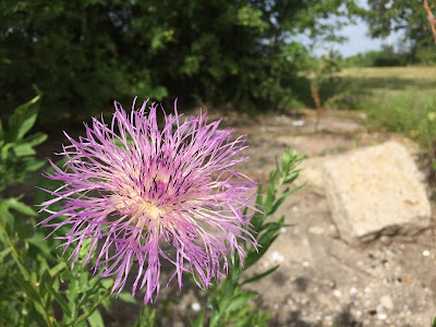 |
| Basket flower among house ruins |
The shoreline is completely open as you leave the ruins and continue walking north along Burnet Bay.
A hundred yards or so up the beach, you will see a concrete
structure. You may not recognize what it is at first, but you are looking at
another swimming pool but from an unexpected vantage point. The bottom edge of the pool rises more than six feet above the ground. Imagine the grassy lawn that used to extend twenty or more yards to the waterfront. This is the best visual lesson in subsidence and beach erosion the Nature Center has to offer. Where my wife Susan is standing in the photograph below, the far edge of the pool is a full foot above her head.
 |
| Susan below the edge of a swimming pool |
This swimming pool may be easier to spot on your initial drive from the visitor center. As Brownwood Drive crosses the water and curves left onto Bayshore Drive, look to the right toward the bay. The pool appears to jut upward and is filled with shrubs and mature trees. The concrete encasement must have provided just the right soil conditions, protecting the trees from the brackish water of Burnet Bay.
 |
| The pool as seen from Bayshore Drive |
Take a shallow dip in the pool and you will enjoy the most extraordinary view of
the bay.
 |
| A dip in the pool |
Running your hands over the cool blue ceramic tile, you will notice that someone, strangely (dangerously), thought this was a good place to do a little target practice.
 |
| Target practice |
After soaking in the pool, head back to your car and drive toward the main entrance of the Nature Center. Just before Brownwood Drive makes a sharp left-hand turn, you will see a large sign on the right for the Golden Bloom Pond Trail. This is my favorite hike in the Nature Center. The trail takes you through the woods and bends around the eastern edge of Cypress Pond before making a sharp turn to the left. A long boardwalk returns you to continue the direction you started, back to a wooded trail that runs along the eastern side of the Nature Center, heading south to Scott Bay. On your left is a chain-link fence, and through it you can see a neighborhood that survived the devastation of Carla, Alicia, and dozens of named and unnamed storms. You are walking along an edge, a zone between ecoregions. You are walking on the dividing line between houses that were deemed habitable and those that were condemned.
 |
| End of the trail—the path to Scott Bay Overlook |
The trail ends at Scott Bay Overlook, a relatively high point on the peninsula, which explains why one neighborhood continued to exist (at least for now) while another sank into history. The overlook offers a stunning view of the bay. Sitting on a covered bench, you can see the Fred Hartman Bridge in the distance. Feeling the sea breeze and looking up into the branches of an enormous shade tree, you might wonder how the tragedy of Brownwood ever came to be.
 |
| Sunflower at land's end |
Walk down to the shore and enjoy, once again, the beautiful wildflowers. Just beyond them are more slabs of concrete and a more substantial bulwark made up of encased steel beams. They are there to protect the shoreline, to hold back the tide. The next time a major storm strikes the Gulf of Mexico and Galveston Bay, however, you can be sure the storm surge will rise above the riprap and steel and wreak havoc on this small peninsula yet again.
 |
| Industrial riprap on Scott Bay |
During my last visit to the Baytown Nature Center, I found a partial brick in the water off Wooster Point. Only half the lettering remained, but the whole brick was originally stamped with the following words: "ACME BRICK CO. EVERLAST." That last one is the most important one and should give each of us pause.
 |
| A potent reminder of human folly |
In my next installment I will consider the signs of Brownwood and the Baytown Nature Center and the stories they tell.


